Where the Escalante River comes from
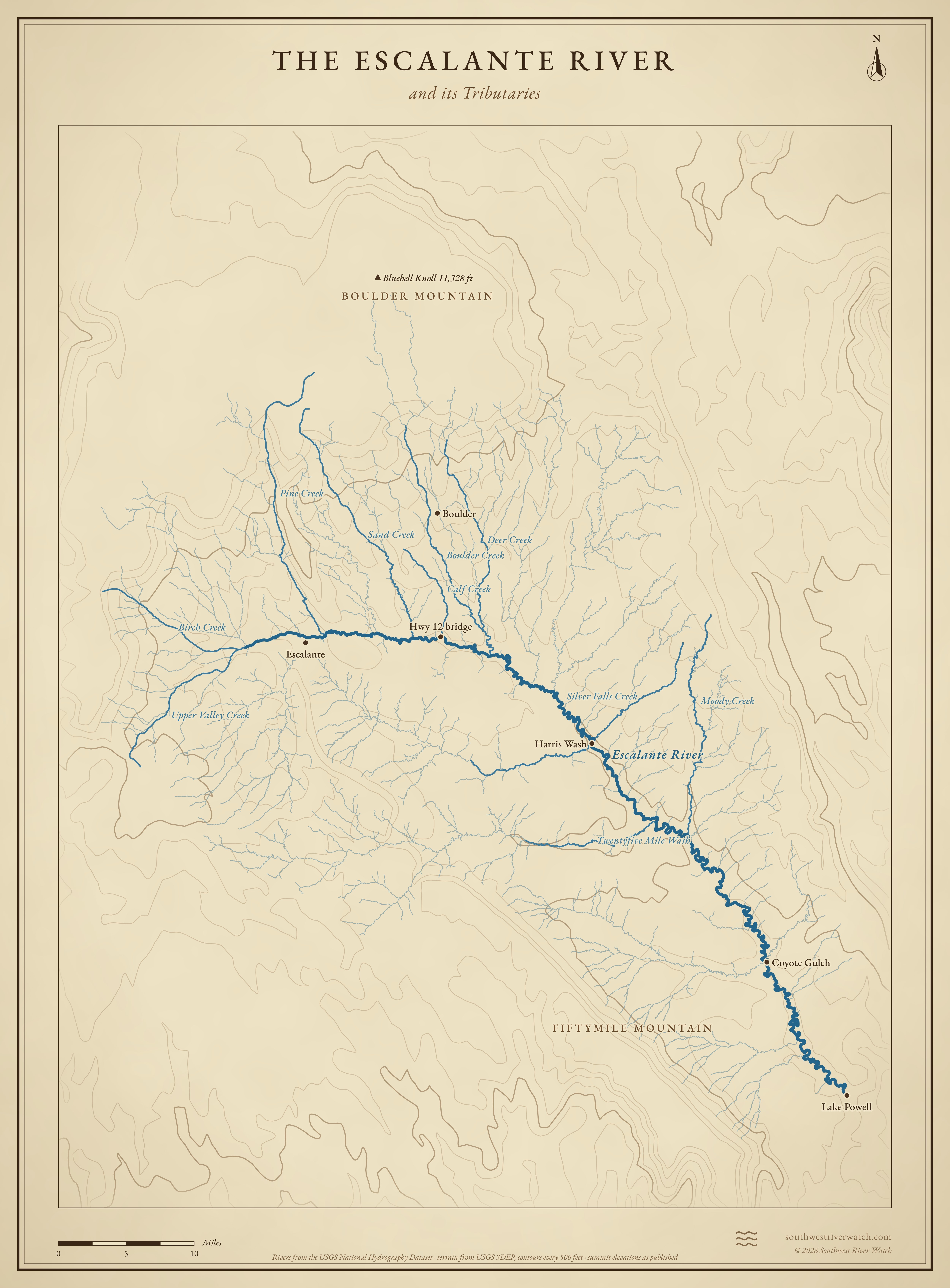
About 90 miles from the high plateaus above the town of Escalante, through a maze of slickrock canyons, to Lake Powell.
 Boulder MountainFiftymile MountainEscalante RiverBluebell Knoll 11,328 ftEscalanteHwy 12 bridgeBoulderHarris WashCoyote GulchLake PowellPine CreekSand CreekBoulder CreekMoody CreekDeer CreekTwentyfive Mile WashBirch CreekSilver Falls Creek10 miles
Headwaters
Creeks off the Aquarius Plateau
The Escalante begins where Upper Valley Creek, Birch Creek and other creeks off the Escalante Mountains meet near the town of Escalante. Pine Creek, coming down from Boulder Mountain on the Aquarius Plateau, joins just below town. The plateau stands over 11,000 feet, and its snowmelt is the river's steady water.1,2
Into the canyons
Below town the river drops into a narrow sandstone canyon and stays in canyons almost all the way to Lake Powell. Side streams from Boulder Mountain (Calf Creek, Boulder Creek and Deer Creek) keep it running year round; the long washes from the south and west are dry most of the time.1,3
The river, top to bottom

- Escalante Mountains & Boulder MountainUpper Valley, Birch and Pine creeks gather at the town of Escalante.
- Escalante CanyonDeath Hollow and Sand Creek come in from the north.
- Highway 12 bridgeCalf Creek joins just above; Lower Calf Creek Falls is up that canyon.
- Boulder CreekJoins with Deer Creek from Boulder Mountain.
- Harris Wash & Twentyfive Mile WashLong desert washes from the Hole-in-the-Rock Road side.
- Moody & Silver Falls creeksCome in from the east, below the Circle Cliffs.
- Coyote GulchThe last big side canyon before the lake.
- Lake PowellThe river meets the lake in Glen Canyon.
Main tributaries
| Stream | Joins | Notes |
|---|---|---|
| Pine Creek | Town of Escalante | From Boulder Mountain; through Box-Death Hollow Wilderness. |
| Calf Creek | Highway 12 | Spring-fed; Lower Calf Creek Falls. |
| Boulder Creek | Below Highway 12 | From Boulder Mountain, by way of the town of Boulder. |
| Harris Wash | Mid canyon | Long wash from the Hole-in-the-Rock Road; dry most of the year. |
| Twentyfive Mile Wash | Mid canyon | Another long desert wash; flashes in storms. |
| Coyote Gulch | Near the lake | Popular hike; Jacob Hamblin Arch. |
Why it matters for floods
Most of the year the Escalante is a small creek. Its floods come from summer and fall thunderstorms over the slickrock and the long desert washes, which can turn the river into a wall of muddy water in minutes, with no gauge on most of the side canyons.1,3 The live map watches the gauges along the way.
The Escalante River and its Tributaries