Virgin River

Virgin River

A small desert river with a big temper: it drains Zion and the Pine Valley Mountains and floods hardest in winter rain-on-snow storms and summer cloudbursts.
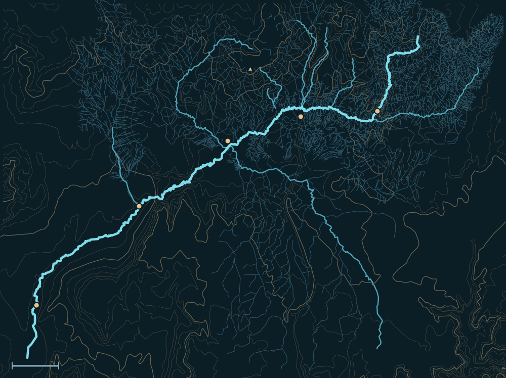
Map of the Virgin RiverPine Valley MountainsVirgin MountainsVirgin RiverSignal Peak 10,365 ftSpringdaleHurricaneSt. GeorgeLittlefieldOvertonFort Pearce WashSanta Clara RiverBeaver Dam WashNorth Creek10 miles
Virgin River. River lines from the USGS National Hydrography Dataset.
The mouth of Zion Canyon below Springdale, where the North Fork of the Virgin leaves it, 1929.
The mouth of Zion Canyon below Springdale, where the North Fork of the Virgin leaves it, 1929.George A. Grant, National Park Service, 1929. U.S. National Archives, public domain · source

People and the river

Alcoves along a big bend of the Virgin in Zion Canyon; the one at right holds part of an ancient cliff-dwelling ruin. 1929.
Alcoves along a big bend of the Virgin in Zion Canyon; the one at right holds part of an ancient cliff-dwelling ruin. 1929.George A. Grant, National Park Service, 1929. U.S. National Archives, public domain · source
Frederick Dellenbaugh, who went down the Colorado with Powell's second expedition in 1871–72, back in Zion in 1929.
Frederick Dellenbaugh, who went down the Colorado with Powell's second expedition in 1871–72, back in Zion in 1929.George A. Grant, National Park Service, 1929. U.S. National Archives, public domain · source
The east portal of the Zion–Mount Carmel tunnel in 1929, a year before the road opened.
The east portal of the Zion–Mount Carmel tunnel in 1929, a year before the road opened.George A. Grant, National Park Service, 1929. U.S. National Archives, public domain · source
Parunuweap Canyon on the East Fork of the Virgin, photographed by the Powell Survey in the 1870s.
Parunuweap Canyon on the East Fork of the Virgin, photographed by the Powell Survey in the 1870s.Powell Survey. U.S. National Archives, public domain · source
  1. For centuriesAncestral Puebloans and then the Southern Paiute farmed along the Virgin and its tributaries.1
  2. 1850s–60sLatter-day Saint settlers built farm towns along the river (St. George in 1861) and spent decades rebuilding diversion dams the floods kept taking.2,3
  3. 1919Zion Canyon, the river's upper gorge, became Zion National Park.1
  4. 1980sQuail Creek Reservoir was built beside the river to store water for the growing St. George area.4

Biggest flows

The Great White Throne above the North Fork, 1929; the photographer noted that its older name, El Gobernador, was going out of use.
The Great White Throne above the North Fork, 1929; the photographer noted that its older name, El Gobernador, was going out of use.George A. Grant, National Park Service, 1929. U.S. National Archives, public domain · source
61,000cfs
Virgin River, Jan 1, 1989, after the Quail Creek dike failed (60,000–66,000 at three gauges)5
measured
37,000cfs
Virgin River at Littlefield, Jan 11, 20056
measured
~6,200cfs
Santa Clara River, Jan 2005 (normal flow is about 5 cfs)7
measured

Measured: a USGS gauge reading. Estimated: reconstructed after the fact from high-water marks or flood deposits. Provisional: USGS readings not yet reviewed.

Floods that mattered

Banks cut away in front of Zion Lodge by the Virgin River's flood of Sept. 1–2, 1929.
Banks cut away in front of Zion Lodge by the Virgin River's flood of Sept. 1–2, 1929.George A. Grant, National Park Service, 1929. U.S. National Archives, public domain · source
More of the Sept. 1929 flood damage along the Virgin in Zion Canyon.
More of the Sept. 1929 flood damage along the Virgin in Zion Canyon.George A. Grant, National Park Service, 1929. U.S. National Archives, public domain · source

Winter 1861–62: the Great Flood

Rain fell for some 44 days. It washed away Fort Clara and parts of Gunlock and Grafton, and is still called the worst flood since settlement.2,3

Jan 1, 1989: Quail Creek dike failure

Seepage cut through the reservoir's dike after midnight, sending about 25,000 acre-feet into the Virgin. Damage topped $12 million.5,4

Jan 2005: Santa Clara and Virgin rivers

Heavy rain on fresh snow set new flow records. About 30 homes in Santa Clara were destroyed or ruined as the river cut away its banks.7,8,6

Sept 14, 2015: Short Creek and Keyhole Canyon

A cloudburst sent Short Creek through Hildale, sweeping away two vehicles and killing at least 12 people, nearly all women and children. The same storms killed 7 canyoneers in Zion's Keyhole Canyon.9,10,11

The Virgin River and its Tributaries
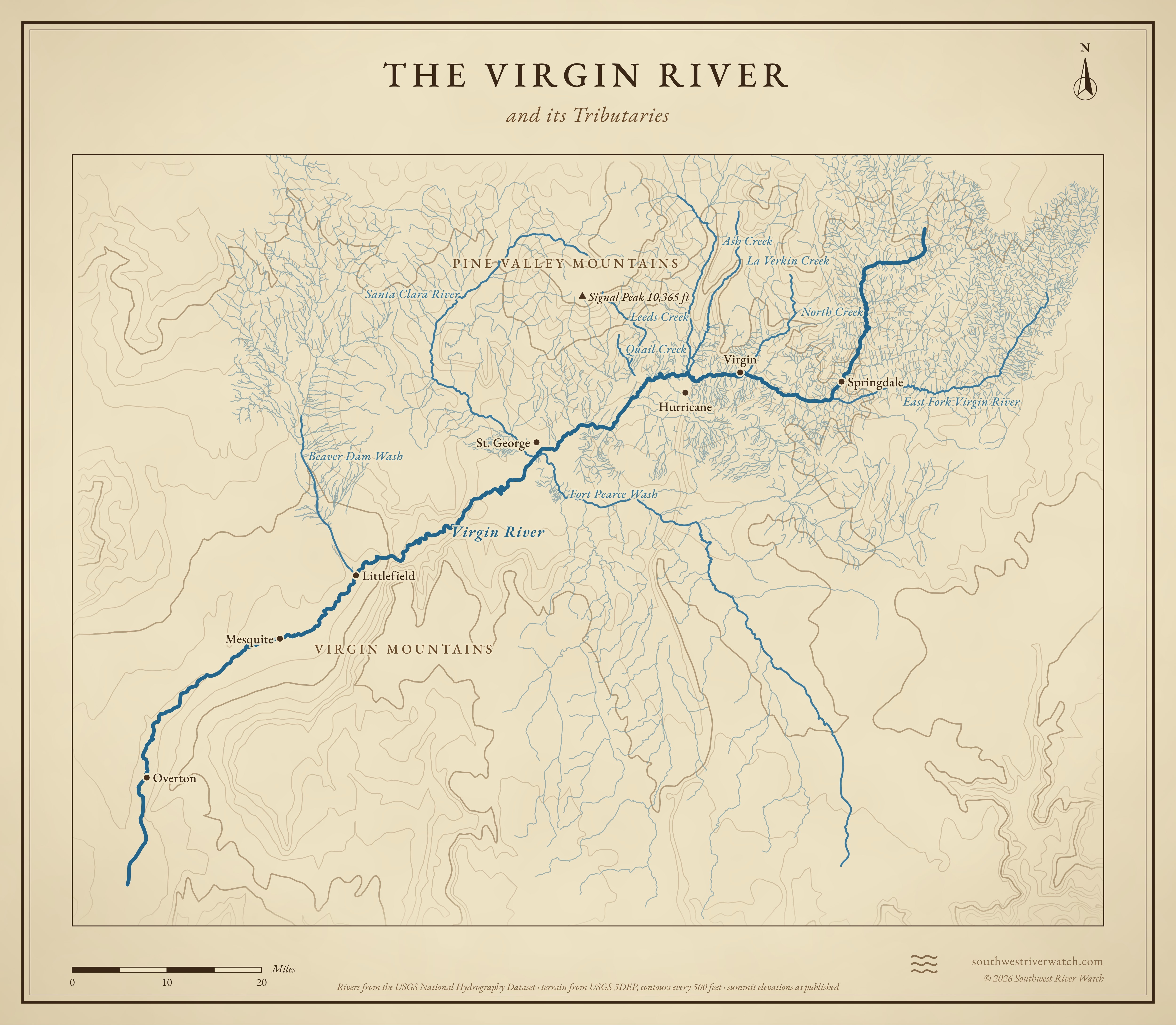
Map of the Virgin River and its tributaries in southwestern Utah, northwestern Arizona and southern Nevada, with Pine Valley Mountains, Virgin Mountains: rivers, side canyons, contour lines and summit elevations, in a classic survey style.
A classic map of the river and the mountains around it. Full size · Vector (SVG) · © 2026 Southwest River Watch
Sources
  1. NPS: Zion National Park history and culture
  2. Washington County Historical Society: Major floods in Washington County
  3. City of Santa Clara: History
  4. ASDSO: Quail Creek dike failure
  5. USGS: Flood on the Virgin River, January 1989 (WRI 94-4159)
  6. USGS: Flooding in Clark and Lincoln Counties, Nevada, Dec 2004 and Jan 2005 (FS 2006-3124)
  7. St George News: Are conditions ripe for a repeat of the 2005 Santa Clara flood?
  8. SERC Carleton: 30 homes lost, lessons from the 2005 Santa Clara flood
  9. AP via WTVR: A trip to the park, then a flash flood (Hildale, Sept 2015)
  10. Weather.com: deaths near the Utah–Arizona border, Sept 2015
  11. NPS: Fatalities in Keyhole Canyon, Zion National Park (Sept 2015)